Understanding Geosteering Techniques
What is Geosteering?
Geosteering is a sophisticated technique used primarily in the oil and gas industry, aimed at optimizing the drilling process. This approach involves the dynamic monitoring and adjusting of drilling operations based on real-time geological data. By integrating geological and geophysical measurements, geosteering enables operators to make informed decisions, ensuring the wellbore is positioned accurately within the desired geological formations. The method leverages advanced technology to enhance drilling efficacy, minimize costs, and reduce environmental impact.
Importance of Real-Time Data
The significance of real-time data in geosteering cannot be overstated. Real-time data acquisition allows for quick analysis and immediate adjustments to drilling trajectory based on the current geological conditions. This responsiveness is crucial, particularly in complex geological environments where formations can shift unexpectedly. Ensuring that drilling teams have access to up-to-the-minute information not only increases the probability of staying on target but also enhances safety and efficiency in operations. Effective geosteering relies on making quick, decisive adjustments to drilling paths, which is only possible with accurate, real-time data.
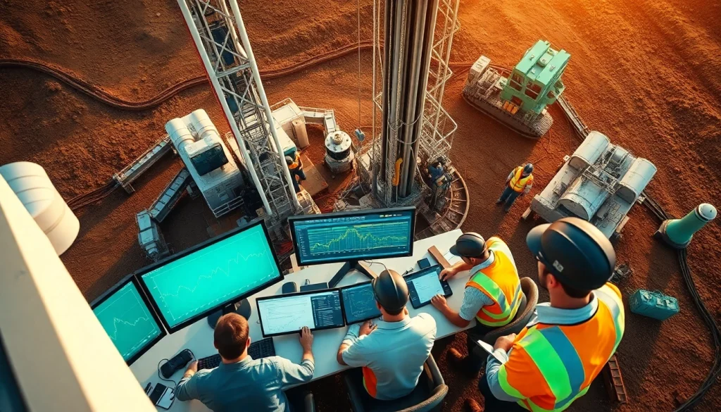
Key Technologies in Geosteering
Modern geosteering utilizes an array of technologies that facilitate real-time analysis and decision-making. These include real-time data visualization tools, advanced software applications for geological modeling, and sophisticated sensors deployed downhole to collect pertinent readings. Technologies such as geological data interpretation software, 3D visualization systems, and machine learning algorithms have revolutionized how geosteering is performed. These innovations help in interpreting complex geological formations, enhancing the precision of drilling operations, and improving overall project outcomes.
Challenges in Geosteering Operations
Common Issues Encountered
While geosteering offers numerous advantages, it is not without its challenges. One of the most common issues is the interpretation of contradictory data, which can lead to incorrect drilling decisions. Additionally, the reliance on high-quality and timely data means that any failure in data collection or transmission can severely impact the operation. Furthermore, operational challenges such as equipment malfunction, harsh environmental conditions, and human errors can complicate geosteering efforts, making it essential for teams to be well-trained and prepared for a variety of scenarios.
Analyzing Geological Variability
Geological formations can exhibit significant variability, posing a critical challenge in geosteering. Understanding these variations requires comprehensive analysis and modeling. Teams must continuously evaluate the geological data as drilling progresses, factoring in parameters like rock properties, pore pressures, and formation fluid compositions. The variable nature of geology demands flexibility and adaptability in geosteering strategies, ensuring that drilling paths are adjusted proactively to stay within productive zones.
Mitigating Operational Risks
Operational risks in geosteering can be mitigated through meticulous planning and execution. Establishing robust safety protocols and ensuring rigorous training for personnel are vital steps in risk management processes. Additionally, employing advanced risk assessment models can help predict potential issues before they arise, allowing teams to make pre-emptive adjustments. Implementing redundancy in data systems and regular maintenance checks on drilling equipment can further decrease the likelihood of operational failures, enhancing the overall stability of the drilling operation.
Implementing Effective Geosteering Strategies
Developing a Geosteering Plan
A well-structured geosteering plan is fundamental for the success of drilling operations. The plan should outline clear objectives, drilling parameters, risk assessments, and defined roles for team members. It should also include a framework for how data will be collected, analyzed, and integrated into decision-making processes throughout the drilling phase. Continuous engagement and communication among all stakeholders ensure that the geosteering plan remains adaptive and responsive to real-time data and changing conditions.
Best Practices for Data Management
Effective data management is crucial in geosteering, as it underpins every decision made during drilling. Establishing standardized protocols for data collection, storage, and sharing can enhance data integrity and accessibility. Utilizing centralized databases allows team members to access the necessary metrics and geological information seamlessly. Implementing data quality checks and validation protocols is vital to ensure that decisions are based on the most accurate information available, as even minor errors can lead to costly drilling missteps.
Collaborative Team Approaches
A collaborative approach is essential in geosteering, as it leverages the diverse expertise of various team members. Effective collaboration hinges on open communication and the integration of multidisciplinary knowledge, including geology, drilling engineering, and geophysics. Regular team meetings to discuss ongoing operations and data analysis play a pivotal role in aligning objectives and ensuring that everyone is on the same page. Such teamwork fosters an environment where innovative solutions can emerge, enhancing the overall geosteering process.
Case Studies and Success Stories
Effective Geosteering in Action
Examining case studies of successful geosteering operations provides insights into best practices and effective methodologies. One notable success involved a drilling project in a high-variability geological zone where real-time data was used to adjust trajectories frequently based on geological feedback. The team implemented a responsive geosteering strategy that resulted in significantly higher production rates compared to traditional drilling techniques, demonstrating the tangible benefits of integrating advanced geosteering practices.
Performance Metrics and Outcomes
Establishing performance metrics is essential in tracking the effectiveness of geosteering strategies. Metrics such as drilling speed, operational costs, and wellbore accuracy offer valuable insights into overall performance. Evaluating these metrics post-operation can help teams identify areas for improvement and foster continuous learning within the organization. Successful projects often report significant reduction in non-productive time and cost savings, underscoring the importance of geosteering in optimizing drilling operations.
Lessons Learned from Successful Projects
Analysis of successful geosteering initiatives reveals numerous lessons that can be applied to future operations. Key takeaways include the importance of investing in training and technology, fostering a culture of collaboration, and remaining adaptable to changing geological conditions. Furthermore, engaging in pre-drilling simulations and scenario planning can prepare teams for various challenges, ensuring they remain agile in their responses during actual drilling operations. These lessons emphasize the need for persistence and innovation in achieving geosteering excellence.
Future Trends in Geosteering
The Role of Artificial Intelligence
The future of geosteering is poised for significant transformation with the incorporation of artificial intelligence (AI). AI can facilitate real-time data processing and predictive analytics, enabling faster and more accurate decision-making. Machine learning algorithms can identify patterns in geological data, assisting in optimizing drilling paths based on predictive models and historical outcomes. The integration of AI into geosteering processes promises to enhance accuracy, reduce costs, and increase overall drilling efficiency, marking a substantial evolution in the field.
Advancements in Data Visualization
Advancements in data visualization technology are revolutionizing how geosteering data is interpreted and utilized. Enhanced graphical representations of geological and drilling data enable clearer insights and faster comprehension among team members. Interactive dashboards, 3D models, and immersive data visualization platforms allow teams to visualize drilling trajectories in relation to geological formations effectively. These advancements not only improve decision-making but also facilitate better communication of complex geological information across disciplines.
Emerging Technologies Impacting Geosteering
Emerging technologies continue to reshape the landscape of geosteering. Innovations such as cloud computing, Internet of Things (IoT) devices, and advanced telemetry systems are enhancing data collection and sharing capabilities. These technologies allow for greater connectivity and integration, ensuring that teams have access to critical data at all times. As new tools and technologies emerge, they hold the potential to further streamline operations, reduce costs, and improve the accuracy of well placement, carving a promising path for the future of geosteering.